
Figure I: 3D magnetometer survey of the fort east of the railway line, looking
west (the bath house is the small block bottom right). The east rampart
and gate are clearly visible (bottom left), also the north rampart and
the gully forming the north ditch. A street runs from the east to the
square headquarters building (top middle). On either side of the street
are pairs of barrack blocks running left to right across the width of
the fort.
One of the major elements of the fieldwork in the 2013
season was the geophysical survey, which was carried out by Geophysical Surveys of Bradford (GSB). They provided training to a number of the volunteers, and at
the same time managed to carry out a magnetometer survey of the fort and bath
house as well as a large part of the surrounding area, some 35 hectares (86
acres) overall. Resistivity survey was also undertaken in certain areas,
totalling about 5 hectares (12 acres). One aim of the work was to check the
results of the original magnetometer survey by Birgit Kaspar of the University
of Birmingham in 2011, which has identified possible Roman features east of the
fort, but we wanted to investigate as wide an area of possible Roman settlement
as possible, north and south of the fort was well as to the east. In addition,
we wanted to investigate the fort and bath house, which had never been subjected
to geophysical survey. So what did we find?

Figure II: Main magnetometer survey, north to top. The fort is bottom left (area
8). Area 7 is part of the vicus along the north coast road. The vicus
east of the fort (lower middle) appears as a mass of features, mostly
rectangular buildings. The Hardknott road (upper centre to top right).
Features on either side of the road (upper centre) indicate more
roadside settlement, which tails off as the road leads away from the
fort. The heavy, dotted linear features with white edges are modern
pipes.
One main result was to confirm that there did indeed appear
to be evidence for a vicus to the
east of the fort, extending in a broad area for about 150m east of the fort.
This eastern vicus is characterised
by rectangular features which was interpreted as ‘strip buildings’; these
usually take the form of long, narrow timber buildings on stone footings, which
lie end-on to the streets in order to maximise the number of properties that
have access to the street frontage and therefore the commercial action. Even
the southern part of the ‘eastern vicus’
seemed to comprise these strip buildings. This finding is contrary to the
original survey, which suggested there were more scattered features in this
area; the revised interpretation is supported by the results from Trench 3.
There is some evidence from the limited surveys north of the fort that there
are buildings, probably a part of the vicus
fronting on to the main road north to Maryport and Hadrian’s Wall. However,
there is no evidence of a vicus south
of the fort.
The buildings north-east of the fort are aligned on a main
road running east-north-east; this is supported by the evidence from Trench 1. The
resistance survey provides a good view of the road, with several side streets
running off it. The latest surveys indicate that this road continues up the
slope and through a shallow valley on to the higher ground, and so is almost
certainly the main Roman road from Ravenglass to Ambleside fort via Hardknott.
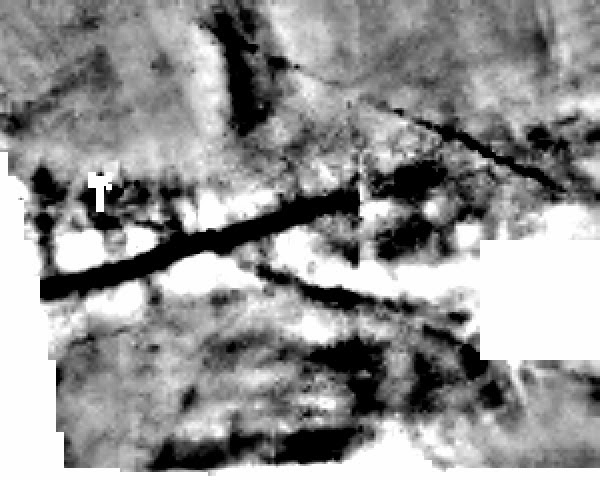
Figure III: Resistivity survey, detail of the Hardknott road, north to top. The road
appears clearly as a dark linear feature (middle left to top right),
with short side streets. The buildings and floor deposits of the
roadside buildings are indicated by the white strips on either side of
the road. The two linear features aligned north-west to south-east
indicate a different phase of activity, possibly earlier than the road
and vicus.
The orientation of the buildings in the eastern vicus is very interesting. In contrast to the east-north-east road observed in Trench 1, the buildings in the southern part (identified in Trench 3) appear to be aligned north-south, which suggests they front on to a street running west-east. Although not as clear as the road to Hardknott, there is a linear feature on the magnetometer survey which may well represent a road running from the east gate of the fort due east for about 200m before turning south-east. Could this be the main road to the south, having to take a detour to avoid a ravine that would have been a major obstruction to a road exiting the south gate? This would explain the absence of a vicus south of the fort. The alignment of the buildings in the central part of the eastern vicus (being investigated in Trench 2) are on yet another aligment, indicating that they respect a minor street running north-east from the fort.
There are numerous other features in and around the vicus, which will require further
investigation to determine whether they are Roman in date. However one feature
of note is that immediately south of the modern boundary separating the two
fields that form the major part of the fieldwork, which appears to be aligned
on the bath house. There is evidence that a lead pipe which would have fed
water from the high ground to the east down to the bath house was unearthed in
the recent past; perhaps this is part of that pipe.
The bath house results are not distinct and suggest much
disturbance from the 19th century excavations. However, the results
from the fort are more useful. The buildings closest to the railway line appear
to be the administrative range, with the principia or headquarters building in
the middle. The eastern part of the fort appears to contain buildings aligned north-south,
probably two pairs of barrack blocks.
The geophysical survey results have provided a wealth of
information that has greatly aided the interpretation of Roman Ravenglass. The
work has raised as many questions as it has answered but that is typical of
archaeological research!
No comments:
Post a Comment